Wednesday, 27 August 2014
Wednesday, 9 April 2014
|
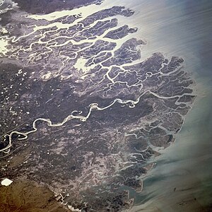
*Route map of river Indus along with its tributaries.
|
The Indus River is one
of the most beautiful rivers of India. Together with its tributaries, the Indus River
forms an important river system, which helps the agricultural economy of India.
The Indus River is an important river, which runs through the entire length of
Pakistan.
Origin of the Indus River
The Indus River originates near the Mansarovar Lake in the Tibetan plateau, on the northern slopes of the Kailash Mountain Range. Regardless of the fact that almost two thirds of the itinerary of the river is flowing through Pakistan, it has its presence on the Indian soil. Parts of the itineraries of the tributaries of the Indus River do run on the Indian soil. The name Punjab has been derived from these tributaries that collectively signify "five waters" or "land of five waters".
Starting off in the Tibetan highland of western China near Lake Mansarovar in Tibet Autonomous Region, the Indus river flows through the Ladakh district of Jammu and Kashmir. Subsequently, the river gets into Pakistan through the Northern Areas (Gilgit-Baltistan), running across the North in a southward route down the whole span of Pakistan, to join the Arabian Sea close to the port city of Karachi situated in Sindh. The Indus River is 3,180 kilometers (1,976 miles) long and it is also the longest river in Pakistan.
Drainage
The Indus River features a total catchment basin of more than 1,165,000 square km (450,000 sq miles). The approximate yearly discharge of the river figures at approximately 207 cubic kilometers, making it the 21st biggest river in the world in terms of yearly discharge. Starting at the pinnacle of the world with glaciers, the Indus River supplies the flora and fauna of temperate forests, plateaus, and dry rural areas. In conjunction with the rivers Chenab, Jhelum, Sutlej, Ravi, Beas and two tributaries from the Afghanistan and Khyber Pakhtunkhwa, the Indus creates the Sapta Sindhu (Seven Rivers) delta of Pakistan.
Description of the
Indus River
The Indus supplies the major water resources for the development of the economy of Pakistan - particularly the Breadbasket of Punjab province, which represents the lion's share of the farming production of the country, and Sindh. The expression Punjab is a portmanteau of two words - panj denoting five, and ab denoting water, offering the simple denotation of the Land of the Five Rivers. The five rivers or Panjnad after which Punjab is named are the Jhelum, Chenab, Ravi, Beas, and the Sutlej. In addition, the river aids several heavy industries and functions as the principal supply of drinkable water in Pakistan.
The origin of the river is located in Tibet; it starts at the meeting point of the Sengge and Gar rivers that sap the Gangdise Shan and Nganglong Kangri mountain ranges. The river subsequently runs to the northwest via Baltistan and Ladakh into Gilgit, immediately south to the Karakoram Mountain range. The Shyok, Gilgit and Shigar rivers transport icy waters into the major river. It slowly turns toward the south, emerging from the hills between Rawalpindi and Peshawar. The river leaves behind enormous canyons with depths of 4,500-5,200 meters (15,000-17,000 feet) in the vicinity of the Nanga Parbat formation. The Indus River runs rapidly through Hazara and is barraged at the Tarbela Reservoir. The Kabul River meets the river close to Attock. The rest of its itinerary to the sea is in the Punjab and Sindh basins and the river gets sluggish and extremely plaited. The Panjnad River meets it at Mithankot. Ahead of this meeting point, the Indus, once upon a time, was called Satnad River (Sat = seven, Nadi = river), as the river was at the moment transporting the waters of Kabul River, the five Punjab rivers, and the Indus River. Going across Jamshoro, it finishes its itinerary in a big delta located to the east of Thatta. Cotton, wheat, and sugarcane are the major agricultural produces of this area.
The Indus is one of the handfuls of rivers in the world that display a tidal bore. The river system is mostly fed by the glaciers and snows of the Himalayan, Hindu Kush, and Karakoram mountain ranges of Tibet, the northern parts of Pakistan, and the state of Jammu and Kashmir respectively. The stream of the river is also decided by the seasons - it reduces significantly in the winter, at the same time overflowing its banks in the monsoon (July to September). Furthermore, there is proof of a stable switch in the itinerary of the river from ancient era - it turned to the west from running into the Rann of Kutch and bordering Banni grasslands following the earthquake in 1816.
Tributaries of the
Indus River
The Indus River has the following tributaries:
·
Astor River
·
Nagar River
·
Dras River
·
Balram River
·
Ghizar River
·
Gar River
·
Gumal River
·
Gilgit River
·
Kurram River
·
Kabul River
·
Shigar River
·
Panjnad River (Created
by the joining of the rivers Chenab, Beas, Jhelum, Ravi, and Sutlej)
·
Sohan River
·
Shyok River
·
Zanskar River
·
Tanubal River
Given below are the five
main tributaries of the Indus River:
Beas
The Beas has its
source in Bias Kund, closely located to the Rohtang pass. The river flows
across Kulu and Manali, where its picturesque basin is named as the Kulu
valley. The Beas meets the Sutlej river close to Harika, after being connected
with some tributaries. The Beas is 615 km long. Running westward, it comes into
India in the Ladakh district of Jammu and Kashmir. The river creates a
beautiful canyon in this area.
Chenab
The Chenab River has its
source at the meeting point of two rivers, the Chandra and the Bhaga. In
Himachal Pradesh, the river is also called the Chandrabhaga. It flows parallely
to the Pir Panjal Range. The river moves into the lands of Punjab in the
vicinity of Akhnur and is subsequently connected with the Jhelum. It creates
the border between the Rechna and the Jech Doabs. The Chenab also meets the
Ravi and the Sutlej in Pakistan. The length of the Chenab River is 960 km.
Jhelum
The Jhelum River
has its source in the south-eastern region of Jammu and Kashmir, in a spring
lying at Verinag. The length of Jhelum river is 480 miles. The river runs
partly in Pakistan and partly in India. The source of the river is situated at
the base of the Pir Panjal range in the south eastern region of the Kashmir
plateau. The river runs through the Wular lake and Srinagar in India, prior to
moving into the Punjab province of Pakistan.
Ravi
The Ravi River has its
source close to the Rotang pass in the Himalayan mountain ranges and runs
according to a north-westerly itinerary. The river shifts to the south-west in
the vicinity of Dalhousie, and subsequently forms a canyon in the Dhaola Dhar
mountain range, penetrating the Punjab valleys close to Madhopur. The Ravi
River runs as a portion of the boundary between India and Pakistan for a
particular distance prior to moving into Pakistan and meeting the Chenab River.
The Ravi River is 720 km long.
Sutlej (Satluj)
The Sutlej River
is also known as the Satluj or the Red River. The source of the river is the
Rakshas Tal or Rakas Lake, which is linked to the Manasarovar Lake with a
watercourse in Tibet. The river moves into Pakistan in the vicinity of
Sulemanki and is subsequently met by the Chenab. The Sutlej is approximately
1,500 km long.
Wildlife of the Indus
River
Chronicles of the Indus valley from the period of Alexander's invasion point towards a sizable woodland encompassing the area, which has greatly diminished as of now. Babur, the famous Mughal Emperor, had mentioned about seeing rhinoceroses beside the riverbanks in the Baburnama (his autobiography). Widespread cutting down of trees and human intervention in the ecosystem of the Shivalik Hills have resulted in a noticeable decline in the quality of foliage and cultivating circumstances. The areas in Indus valley are dry with meagre plantation. Cultivation is mostly dependent on irrigation water.
Platanista gangetica minor or the blind Indus River Dolphin is a breed of dolphin seen only in the Indus River. Earlier, the dolphin was also found in the tributaries of the Indus River. Palla fish (Hilsa) of the Indus River is a preferred food choice for inhabitants staying on the banks of the river. The number of fishes in the river waters is reasonably high. Thatta, Sukkur, and Kotri are the important fishing hubs - all located in the lower Sindh itinerary. However, irrigation and barraging has made fish cultivation a significant economic line of business. The big Indus valley delta is situated to the southeast of Karachi and it has been acknowledged by environmentalists to be one of the most significant ecological areas in the world. In this area, the river converts into several wetlands, torrents, and tributaries and joins the sea at low levels. You will see plenty of sea fishes and other creatures in this area, which include prawns and pomfret.
People living on the
banks of the Indus River
The inhabitants of the areas through which the Indus River flows on and creates
a significant natural beauty and wealth, are varied in terms of faith, race,
national and language settings.
In the district of Jammu and Kashmir on the northern itinerary of
the river reside the Buddhist inhabitants of Ladakh, people of Tibetan
ancestry, and the Dards of Dardic or Indo-Aryan ancestry who follow Islam and
Buddhism. Subsequently, the river goes down into Baltistan in north Pakistan,
going by the important Balti city of Skardu. While the river flows through
Pakistan, it creates a characteristic border of society and traditions. On the
western banks of the river, the people are mostly of Baloch, Pashtun, and other
Iranic ancestry, with intimate economic, traditional, and communal ties with
areas of Iran and East Afghanistan. The eastern banks of the Indus River are
mostly inhabited by citizens of Indo-Aryan ancestry like the Sindhis and the
Punjabis. In the Khyber Pakhtunkhwa and northern Punjab, tribal Pashtun people
stay together with Dardic populace in the hills (Kalash, Khowar, Shina, and
others), Burushos (in Hunza), and Punjabi individuals. People of Sindhi
ancestry mostly inhabit the Sindh province. People of Pashtun and Baloch
background inhabit on the western banks of the river.
Tuesday, 8 April 2014
· The Indus River is a
major river in Asia which flows through
Pakistan.
It also has courses through western Tibet and
Northern
India.
· Discharge: 6,600
m³/s
The Indus (known as
Sindhu in ancient times) is the principal river of Pakistan. It flows from the
Himalayas approximately southwest to the Arabian Sea. India is named after it.
The Indus Valley Civilization was one of the oldest urban civilizations in the
world.
The ultimate source of the Indus is actually in Tibet; it begins
at the confluence of the Sengge River and Gar River that drain the Nganglong
Kangri and Gangdise Shan ranges. The Indus then flows northwest through Kashmir
just south of the Karakoram range, then gradually bends to the south, coming
out of the hills between Peshawar and Rawalpindi. It is dammed in this area
also, forming the Tarbela Reservoir. The remainder of its route to the sea is
in plains of the Punjab and Sind, and the river becomes slow-flowing highly braided.
Passing by Hyderabad, it ends in a large delta to the southeast of Karachi that
has now been recognised by conservationists as one of the world's most
important ecological regions.
The Indus River Dolphin, modern genetic studies show, lives both
in the Indus River and in the Ganges. The two populations were formerly
considered distinct species. It formerly occurred in the tributaries of the
Indus also and may have extended into the northwestern extremities of the
Indian Province of Punjab.
The Indus is one of the few rivers in the world that exhibit a
tidal bore. A tidal bore (or just bore) is a tidal phenomenon in which the
leading edge of the incoming tide forms a wave (or waves) of water that travel
up a river against the direction of the current. As such, it is a true tidal
wave.
The upper Indus plain is drained by the Indus together
with itstributaries,the Jhelum, Chenab, Ravi, Beas, and Sutlej rivers, forming
a developed system of interfluves,
known locally as doabs,
in Punjab province
(Persian panj āb, “five waters,” in reference to the five
rivers). In the lower plain the Indus River has a Nilotic character; i.e., it
forms a single large river with no significant tributaries. The plain narrows
to form a corridor near Mithankot, where the Sulaiman Range comes close to the
plain and the Indus merges with its last major tributary, the Panjnad River (which
is itself merely the confluence of the five Punjab rivers). Flooding is a
perennial problem, especially along the Indus, as a consequence of heavy rains
(usually in July and August).
Indus, the Lion River
   |

If
there was no Indus river, there would not
have no people living in this part of the
world. Originating from the glacial
Tibetan
mountains, the Indus gushes into
Pakistan with all its might and fright from
the northern areas. Near Attock,
the
River Kabul also joins this ferocious river
and one can vividly see the blue Kabul River merging with the muddy Indus
while standing on the bridge over Indus at Attock. Both join hands together
and irrigate the entire length of Pakistan, approximately 2,900 km (1,800
mi), till it steadily calms down and fades away in the Arabia Sea.
Besides Indus, four other rivers also enter
Pakistan from the neighboring India, namely the Jhelum, Chenab, Ravi and
Sutlej and all empty into the Indus to add to its might and power. The place
where all these four rivers meet the Indus is known as "Panj Nadh
(meaning in local language Five Rivers) south of the famous ancient city of
Multan.
Having almost lost its impetus near the Arabia Sea, it fans out and forms the Indus Delta. Here the forests of mangroves and many a species of birds and fish flourish on the sweet waters of the Indus. The total area of the deltas that includes swamps and mangroves is approximately 225,000 hectares (556,000 acres). The port city of Karachi and marches of Ran of Kutch shoulder this delta during its final stages of journey.
Cities that
Indus Passes By: The Indus skirts and passes by the famous Attock, Bannu,
Faisalabad, Multan, Khairpur, Sukkur, Larkana, Nawabshah, Mirpurkhas, Hyderabad
and finally embracing the Arabian Sea near the port city of Karachi (above).
The Indus Delta
The Indus
Delta is the fifth largest delta in the world, characterized by high river
discharge, moderate tides, and evidently
the highest wave energy of any river in the world. The fan-shaped
delta consists of creeks, estuaries, mud, sand, salt flats, mangrove habitat,
marshes, sea bays, and straits and rocky shores. Its 129,000 ha. of mangrove,
mostly Avicenna marina, comprises 97% of the total mangrove area in the
country and is said to be the 7th largest
mangrove forest in the world. The area is rich in archaeological
and religious heritage.
The Indus River "Blind"
Dolphin

The Indus
River harbors the rare species of nearly blind dolphin. The dolphin lacks eye
lenses and the eye openings are no bigger than a pinhole. As a result, these
rely almost entirely on echolocation to forage for food and navigate in the
murky river waters.
The Indus Dolphin has a long beak, a small, low hump, wide flippers and an adult can weigh 70- 90 kg. They are slow swimmers, but can move in rapid spurts. They breathe through their slit - like blowholes with a loud sound that is similar to a sneeze, and can be heard from quite a distance." It sometimes carries its young on its back, above the surface of the water. These are found in a localized 100 mile stretch between the Sukkur and Guddu Barrages in Indus River. The dolphin, also known as Indus Susu, is one of the five species of cetaceans that are threatened with extinction, presently no more than 500 animals remaining. The Indus dolphin has been a victim of both deliberate and accidental exploitation. ThePakistan Adventure Foundation, a project funded by the UN Development Programme, is trying to create awareness about the endangered blind dolphin through rafting expeditions and visiting riverside fishing communities. |

|
|
|
|
|
Tuesday, 4 February 2014
Q: What is
the difference between weathering and erosion?
Weathering is the process of decomposing,
breaking up, or
changing the
color of rocks. Weathering may be caused by the action of water, air,
chemicals, plants, or animals.
Chemical
weathering involves chemical changes in the minerals of the rock, or on
the surface of the rock, that make the rock change its shape or color. Carbon
dioxide, oxygen, water, and acids may all cause chemical weathering.
Mechanical weathering is the process of breaking a large
rock into smaller pieces
without
changing the minerals in the rock. Mechanical weathering may be caused by
frost, ice, plant roots, running water, or heat from the sun.
Once the small pieces of rocks are changed or
broken apart by weathering, they may start to be moved by wind, water, or ice.
When the smaller rock pieces (now pebbles, sand or soil) are moved by these
natural forces, it is called erosion.
So, if a rock is changed or broken but stays where it is, it is called
weathering. If the pieces of
weathered rock are moved away, it is called erosion.

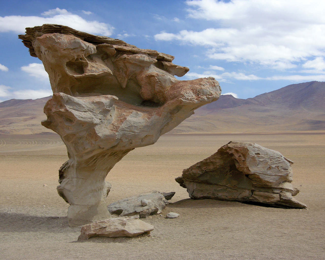
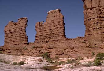
Images for
weathering and erosion:
Weathering and Erosion


Release of pressure from the rock


Subscribe to:
Posts (Atom)