· The Indus River is a
major river in Asia which flows through
Pakistan.
It also has courses through western Tibet and
Northern
India.
· Discharge: 6,600
m³/s
The Indus (known as
Sindhu in ancient times) is the principal river of Pakistan. It flows from the
Himalayas approximately southwest to the Arabian Sea. India is named after it.
The Indus Valley Civilization was one of the oldest urban civilizations in the
world.
The ultimate source of the Indus is actually in Tibet; it begins
at the confluence of the Sengge River and Gar River that drain the Nganglong
Kangri and Gangdise Shan ranges. The Indus then flows northwest through Kashmir
just south of the Karakoram range, then gradually bends to the south, coming
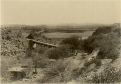
out of the hills between Peshawar and Rawalpindi. It is dammed in this area
also, forming the Tarbela Reservoir. The remainder of its route to the sea is
in plains of the Punjab and Sind, and the river becomes slow-flowing highly braided.
Passing by Hyderabad, it ends in a large delta to the southeast of Karachi that
has now been recognised by conservationists as one of the world's most
important ecological regions.
The Indus River Dolphin, modern genetic studies show, lives both
in the Indus River and in the Ganges. The two populations were formerly
considered distinct species. It formerly occurred in the tributaries of the
Indus also and may have extended into the northwestern extremities of the
Indian Province of Punjab.
The Indus is one of the few rivers in the world that exhibit a
tidal bore. A tidal bore (or just bore) is a tidal phenomenon in which the
leading edge of the incoming tide forms a wave (or waves) of water that travel
up a river against the direction of the current. As such, it is a true tidal
wave.
The upper Indus plain is drained by the Indus together
with itstributaries,the Jhelum, Chenab, Ravi, Beas, and Sutlej rivers, forming
a developed system of interfluves,
known locally as doabs,
in Punjab province
(Persian panj āb, “five waters,” in reference to the five
rivers). In the lower plain the Indus River has a Nilotic character; i.e., it
forms a single large river with no significant tributaries. The plain narrows
to form a corridor near Mithankot, where the Sulaiman Range comes close to the
plain and the Indus merges with its last major tributary, the Panjnad River (which
is itself merely the confluence of the five Punjab rivers). Flooding is a
perennial problem, especially along the Indus, as a consequence of heavy rains
(usually in July and August).
Indus, the Lion River
   |

If
there was no Indus river, there would not
have no people living in this part of the
world. Originating from the glacial
Tibetan
mountains, the Indus gushes into
Pakistan with all its might and fright from
the northern areas. Near Attock,
the
River Kabul also joins this ferocious river
and one can vividly see the blue Kabul River merging with the muddy Indus
while standing on the bridge over Indus at Attock. Both join hands together
and irrigate the entire length of Pakistan, approximately 2,900 km (1,800
mi), till it steadily calms down and fades away in the Arabia Sea.
Besides Indus, four other rivers also enter
Pakistan from the neighboring India, namely the Jhelum, Chenab, Ravi and
Sutlej and all empty into the Indus to add to its might and power. The place
where all these four rivers meet the Indus is known as "Panj Nadh
(meaning in local language Five Rivers) south of the famous ancient city of
Multan.
Having almost lost its impetus near the Arabia Sea, it fans out and forms the Indus Delta. Here the forests of mangroves and many a species of birds and fish flourish on the sweet waters of the Indus. The total area of the deltas that includes swamps and mangroves is approximately 225,000 hectares (556,000 acres). The port city of Karachi and marches of Ran of Kutch shoulder this delta during its final stages of journey.
Cities that
Indus Passes By: The Indus skirts and passes by the famous Attock, Bannu,
Faisalabad, Multan, Khairpur, Sukkur, Larkana, Nawabshah, Mirpurkhas, Hyderabad
and finally embracing the Arabian Sea near the port city of Karachi (above).
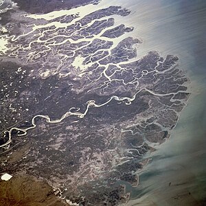
The Indus Delta
The Indus
Delta is the fifth largest delta in the world, characterized by high river
discharge, moderate tides, and evidently
the highest wave energy of any river in the world. The fan-shaped
delta consists of creeks, estuaries, mud, sand, salt flats, mangrove habitat,
marshes, sea bays, and straits and rocky shores. Its 129,000 ha. of mangrove,
mostly Avicenna marina, comprises 97% of the total mangrove area in the
country and is said to be the 7th largest
mangrove forest in the world. The area is rich in archaeological
and religious heritage.
The Indus River "Blind"
Dolphin

The Indus
River harbors the rare species of nearly blind dolphin. The dolphin lacks eye
lenses and the eye openings are no bigger than a pinhole. As a result, these
rely almost entirely on echolocation to forage for food and navigate in the
murky river waters.
The Indus Dolphin has a long beak, a small, low hump, wide flippers and an adult can weigh 70- 90 kg. They are slow swimmers, but can move in rapid spurts. They breathe through their slit - like blowholes with a loud sound that is similar to a sneeze, and can be heard from quite a distance." It sometimes carries its young on its back, above the surface of the water. These are found in a localized 100 mile stretch between the Sukkur and Guddu Barrages in Indus River. The dolphin, also known as Indus Susu, is one of the five species of cetaceans that are threatened with extinction, presently no more than 500 animals remaining. The Indus dolphin has been a victim of both deliberate and accidental exploitation. ThePakistan Adventure Foundation, a project funded by the UN Development Programme, is trying to create awareness about the endangered blind dolphin through rafting expeditions and visiting riverside fishing communities. |

|
|
|
|
|
No comments:
Post a Comment